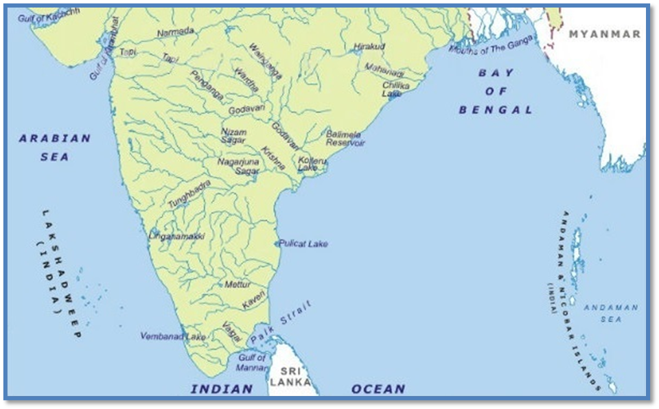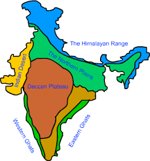
Peninsular River - Evolution
- Three important geological occurrences in the distant past shaped Peninsular India's current drainage networks.
- During the early tertiary era, the western flank of the Peninsula began to sink, resulting in its submergence beneath the sea.
- In general, it has disrupted the river's symmetrical layout on both sides of the original watershed.
- The Himalayas were upheaved when the peninsular block's northern flank was subjected to subsidence and trough faulting.
- The Narmada and Tapi rivers run across faults, filling the original fractures with sediment.
- As a result, alluvial and deltaic deposits are scarce in these rivers.
- During the same era, a little tilt of the peninsular block from northwest to south-eastern imparted orientation to the whole drainage system towards the Bay of Bengal.
Smaller Rivers of India flowing towards West
- The rivers that feed into the Arabian Sea have very short courses.
- These west-flowing rivers will eventually reach the Arabian Sea.
Sabarmati River
- One of India's most major west-flowing rivers is the Sabarmati.
- It starts in the Aravalli Range in Rajasthan's Udaipur District and finishes at the Arabian Sea's Gulf of Khambhat after travelling 371 kilometres through Rajasthan and Gujarat.
- The Aravalli hills border the basin on the north and north-east, the Rann of Kutch on the west, and the Gulf of Khambhat on the south.
- The Watrak, Wakal, Hathmati, Harnav, and Sei rivers are the major tributaries.
Mahi River
- Western India is home to the Mahi River.
- It starts in Madhya Pradesh and flows through Rajasthan's Vagad region before entering Gujarat and emptying into the Arabian Sea.
- The Aravalli hills surround it on the north and north-west, the Malwa Plateau on the east, the Vindhyas on the south, and the Gulf of Khambhat on the west.
- Mahi is a major interstate west-flowing river in India.
- Som is a right bank tributary of Mahi river.
- Anas and Panam rivers are the tributaries of Mahi on the left bank.
Dhandhar River
- Its origins may be traced back to Jamnagar's Lalpur district.
- The main fluvial sedimentary facies of the Late Pleistocene deposits in the Dhadhar River basin have preserved palaeo-drainage signals and may serve as an important link between the sub-humid Narmada basin in the south and the semi-arid Mahi basin in the north.
- Vishwamitri, Jambuo, Dev, and Surya rivers are significant tributaries of the Dhadhar river.
Sharavati River
- The Sharavati River flows through the Indian state of Karnataka.
- It begins in the Western Ghats and goes northwest for 60 miles (100 kilometres) to Honavar on the Arabian Sea.
- Ambuthirtha is a mountain in Shimoga District, Karnataka, India, near the village of Thirthahalli. It is the source of the Sharavathi River.
- The river basin of the Sharavati is extensively wooded.
- Nandihole, Haridravathi, Mavinahole, Hilkunji, Yennehole, Hurlihole, and Nagodihole are the river's principal tributaries.
Bharathapuzha River
- The Bharathapuzha River, which flows into the Arabian Sea, is Kerala's second longest West Flowing River.
- It is bounded on the east by the Cauvery basin and on the west by the Arabian Sea.
- Bharathapuzha is a river in Kerala, India. It is also known as the Nila, Ponnani, or Kuttippuram River.
- The main course of the Bharathapuzha begins as a series of minor rivulets in the Western Ghats near the Anamalai hill ranges in Tamil Nadu.
- The three major tributaries are the Gayathripuzha, Kalpathipuzha, and Pulanthode.
Periyar River
- The source of the Periyar lies high in the Western Ghats. The Periyar River begins on the southeastern edge of the Idukki district.
- The river's headwaters are in the isolated woods of the Periyar Tiger Reserve.
- According to various reports, the river's source is Chokkampatti Mala, a hill on the southern fringe of the Periyar Tiger Reserve.
- The Periyar River originates in the Sivagiri Hills of the Western Ghats and flows through the Periyar National Park.
- It ultimately drains into Vembanad Lake, which finally empties into the Arabian Sea.
- The Periyar River is the longest and has the highest discharge capacity in the Indian state of Kerala.
- Muthirapuzha River, Mullayar River, Cheruthoni River, Perinjankutti River, and Edamala River are its primary tributaries.
- Muthayar, Perunthuraiar, Chinnar, Cheruthony, and Kattappanayar are minor tributaries.
Small Rivers Flowing towards the East
- A huge number of rivers, as well as their tributaries, flow to the east.
- There are several tiny rivers that connect to the Bay of Bengal, and while they are little, they are significant in their own way.
Subarnarekha River
- It begins at an elevation of 600 metres in Nagri hamlet in Jharkhand's Ranchi area.
- It is bounded on the north-west by the Chota Nagpur Plateau, on the south-west by the Brahmani basin, on the south by the Burhabalang basin, and on the south-east by the Bay of Bengal.
- Hundru Falls, which falls from a height of 98 metres, is produced along the Subarnarekha River.
- The numerous rock formations developed as a consequence of erosion by the constantly running water have contributed to the area's allure.
- The Subarnarekha's major tributaries are the Kharkai, Roro, Kanchi, Harmu Nadi, Damra, Karru, Chinguru, Karakari, Gurma, Garra, Singaduba, Kodia, Dulunga, and Khaijori.
Baitarani River
- The Baitarani is a large east-flowing river in peninsular India that finally flows into the Bay of Bengal.
- The Baitarani flows through the Gonasika hills and through a stone shaped like a cow's nose.
- The Baitarani is known as Guptaganga or Gupta Baitarani in the Indian state of Odisha.
- Baitarani's commencement is a short stretch of the boundary between the states of Odisha and Jharkhand.
- Baitarani's tributaries are the Budhi, Kanjori, Ambajhara, Mushal, Kusei, and Salandi.
Brahmani River
- The Brahmani river originates in Nagri village in Jharkhand's Ranchi area at a height of around 600 metres and travels for 799 kilometres.
- The Brahmani River flows south through the valleys created by the Garhjat Hills to reach the well-known Gangpur Basin. In this location, the Brahmani River is joined by a number of fast-flowing tributaries.
- The deltaic zone of Brahmani begins 315.00 kilometres downstream from Jenapur, when the Kalamitra island divides the river into two streams.
- Brahmani tributaries include Koel, Kuradhi, Mankara, Samakoi, Ramiala, Karo, Sankh, Rukura, Gohira, Tikira, Singdajhor, Nigra, Barjor, and Nandira.
Pennar River
- The Pennar River, also known as the Uttara Pinakini in India, is a river.
- The Pennar River is a vital waterway in Peninsular India.
- Pennar River begins in Karnataka's Nandi highlands' Chenna Kesava hills and flows for around 597 kilometres before draining into the Bay of Bengal.
- The Pennar and its tributaries watershed span a section of the southern Deccan plateau, including the bulk of Andhra Pradesh's Rayalaseema region and a piece of Karnataka.
- The Kolar Plateau divides the Pennar watershed from the Kaveri, Ponnaiyar, and Palar river basins to the south.
- The river's major tributaries are the Jayamangal, Kunder, Sagileru, Chitravati, Papagni, and Cheyyeru.
Palar River
- It starts in Karnataka's Chikkaballapur district and goes through Karnataka, Andhra Pradesh, and Tamil Nadu until entering the Bay of Bengal at Vayalur, south of Chennai.
- The flow of the Palar is unpredictable, with large variations from year to year.
- The Palar Basin is one of the most significant of the 12 basins that connect the Pennar and Cauvery basins.
- The river Palar is fed by two major tributaries: the Ponni on the left bank and the Cheyyar on the right


