It originates from a glacier near Bokhar Chu in the Tibetan region at an altitude of 4,164 m in the Kailash Mountain range near the Mansarovar Lake.
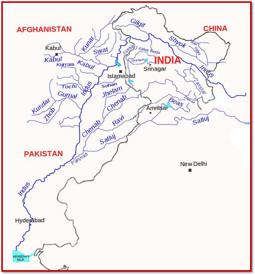
Left and Right bank tributaries
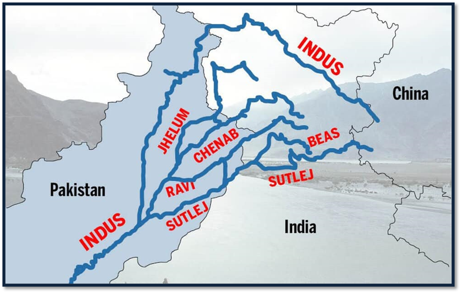
- Zaskar river, Suru river, Soan river, Jhelum River, Chenab River, Ravi River, Beas river, Satluj river, Panjnad river are its major left-bank tributaries.
- Shyok River, Gilgit river, Hunza river, Swat river, Kunnar river, Kurram river, Gomal River, and Kabul river are its major right-bank tributaries.
Shyok River
- Rising from the Karakoram Range, it flows through the Northern Ladakh region in J&K
- It has a length of about 550km.
- A tributary of the Indus River, it originates from the Rimo Glacier.
- The river widens at the confluence with the Nubra River
- Shyok River marks the south-eastern fringe of the Karakoram ranges by forming a V-shaped bend around it.
Nubra River
- It is the main tributary of the Shyok River.
- It originated from the Nubra Glacier, in a depression to the east of Saltoro Kangri Peak
- Nubra River meanders towards the southeast to join the Shyok River downstream of Shyok Valley at the base of the Ladakh range
- Nubra Valley, situated at an altitude of 3048m, is formed out of the Nubra River
- The catchment area is devoid of vegetation and human habitation due to high elevation and lack of rainfall.
Shigar River
- It is a small right-bank tributary of the Indus River in its course through the Ladakh region of J&K
- It rises from the Hispar Glacier.
- It joins Indus at Skardu.
- The Shigar River descends down a very steep gradient
- Its entire catchment has been influenced by the action of glaciers.
Gilgit River
- It is an important right-bank tributary of the Indus River in its course through the Ladakh region of J&K
- It originates from a glacier near the extreme northwestern boundary of the Himalayas
- The entire catchment area of the Gilgit River is bleak and desolate
- Bunji is the main human settlement along the river
- Ghizar and Hunza are the major right and left bank tributaries respectively.
Hunza River
- It is an important left-bank tributary of the Gilgit River
- It rises from a glacier north of the Karakoram Range in the northwestern part of J&K
- It flows southeast and cuts across the Karakoram Range through a spectacular gorge
- Downstream, the Hunza River follows a southwesterly direction in its middle course
- Then it cuts across an offshoot of the Karakoram range and changes course to the southeast in its lower course before merging with the Gilgit a little upstream of Bunji where the latter river empties itself into the Indus.
Zanskar River
- It is one of the important left blank tributaries of the Indus
- Human settlements are sparse.
Chenab River
- The Chenab originates from near the Bara Lacha Pass in the Lahul-Spiti part of the Zaskar Range.
- Chenab river is formed by the confluence of the Chandra and Bhaga rivers at Tandi located in the upper Himalayas in the Lahul and Spiti District of Himachal Pradesh
- In its upper reaches, it is also known as the Chandrabhaga
- It flows through the Jammu region of J&K into the plains of Punjab in Pakistan
- The waters of the Chenab are allocated to Pakistan under the terms of the Indus Water Treaty
- Baghliar Dam has been constructed on this river
- The river is crossed in J&K by the world’s highest railways bridge name Chenab Bridge.
Jhelum River
- It is a tributary of the Chenab River and has a total length of 813km
- The river Jhelum rises from a spring at Verinag situated at the foot of the Pir Panjal in the southeastern part of the valley of Kashmir in India.
- The Kishenganga (Neelum) River, the largest tributary of Jhelum, joins it.
- The Chenab merges with the Sutlej to form the Panjnad River which joins the Indus River at Mithankot
- The waters of the Jhelum are allocated to Pakistan under the terms of the Indus WatersTreaty
- It ends in a confluence with the Chenab in Pakistan.
Kishanganga River
- It originates at Drass in the Kargil district of J&K
- The Neelam River enters Pakistan from India near the Line of Control and then runs west till it meets the Jhelum River
- It is also called as Neelam River (Neelum) either due to its sky cold water or due to the precious stone “ruby (Neelam)” that is found in this area
- It is famous for ice-cold water and trout fish.
Ravi River
- The Ravi River originates Dhauladhar range of the Himalayas in the Chamba district of HP. Ravi has its source in Kullu hills near the Rohtang Pass in Himachal Pradesh.
- It follows a northwesterly course and is a perennial river having a total length of about 720km
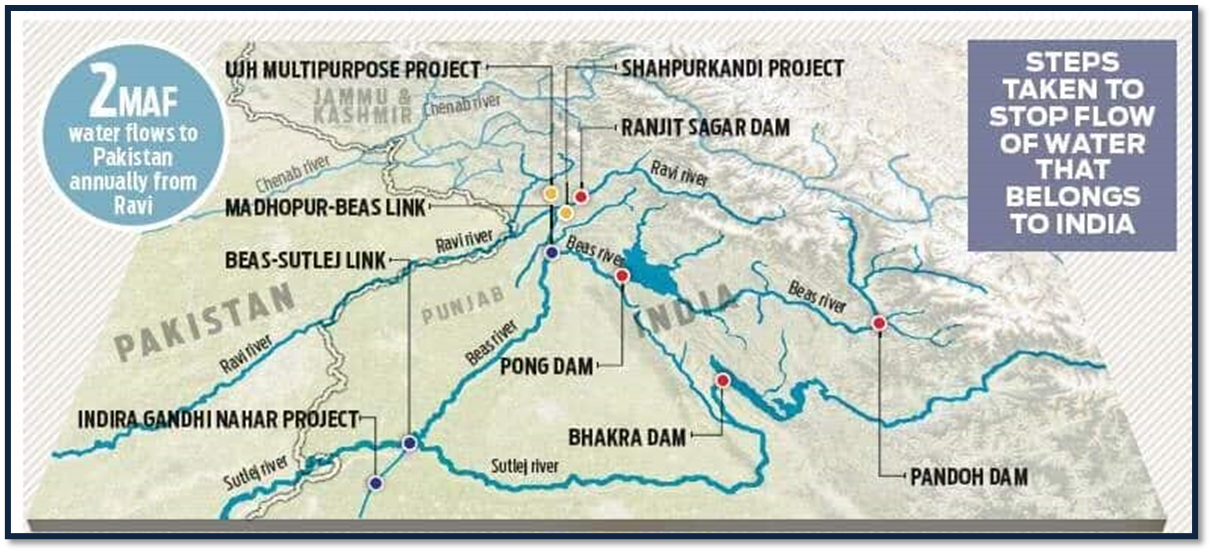
- The waters of the Ravi River are allocated to India under the Indus Waters Treaty
- The major multipurpose project built on the river is the Ranjit Sagar Dam ( Thein dam as it is located in Theinvillage)
- Chamba town is situated on the right bank of the river.
- The right bank tributaries of the Ravi are the Budhil, Tundahan Beljedi, Saho and Siul; and its left bank tributary worth mentioning is Chirchind Nala.
- The Ujh river is a tributary of the Ravi River that flows through the Kathua district in the Indian union territory of Jammu and Kashmir.
- Ujh Multipurpose Project is planned to be constructed in Kathua District of Jammu & Kashmir on the River Ujh.
- Shahpurkandi Dam project is located on the Ravi River in Pathankot district, Punjab, downstream from the existing Ranjit Sagar Dam.
Sutlej River
- The Sutlej is sometimes known as the Red River.
- It rises from beyond the Indian borders in the southern slopes of the Kailash Mountain near Mansarover Lake from Rakas Lake.
- It enters HP at Shipki La and flows in the South-westerly direction through Kinnaur, Shimla, Kullu, Solan, Mandi, and Bilaspur districts.
- It leaves HP to enter the plains of Punjab at Bhakra, where the world’s highest gravity dam- Bhakra Nangal Dam, has been constructed on this river.
- The waters of the Sutlej are allocated to India under the Indus Water Treaty b/w India and Pakistan and is mainly used for power generation and irrigation of many large canals draw water from it
- Across the river, there are many hydroelectric and irrigation projects such as the Kol Dam, Nathpa Jhakri project.
Beas River
- Beas River, an important river of the Indus River System, emerges from Rohtang pass in HP
- The river before entering Pakistan merges with the Sutlej River at Hari-Ke-Pattan in Punjab
- The total length of this river is 460km and the river covers 256km through HP
- The tourist resorts of Manali is situated on the right banks of the River Beas.


